Map of Outer Banks NC
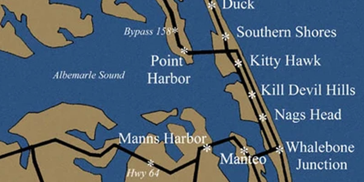
As the Outer Banks of North Carolina offers visitors more enjoyment and relaxation every year, routes to and from the area continue to be improved and expanded.
The Monitor-Merrimac Memorial Bridge-Tunnel in Hampton Roads, Virginia, and the expansion from two to four lanes of the Wright Memorial Bridge, linking Currituck to the Outer Banks, make access more convenient.

Routes to the Outer Banks
From Washington DC/Richmond, VA
Follow I-64 through the Hampton Roads Bridge-Tunnel (a busy route on weekends) to Great Bridge, VA. Go south on VA-168 to US-158 East at Barco, NC. Follow US-158 to the Outer Banks.
From Washington DC/Richmond, VA
Get off I-64 at Hampton, VA. Go south on I-664 through the Monitor-Merrimac Memorial Bridge-Tunnel. Take I-64 toward Norfolk/Virginia Beach; then go south on US-17 at Deep Creek, VA to South Mills, NC. Follow NC-343 south to US-158 South.
From the Eastern Shore and North
Take US-13 South from Chesapeake Bay Bridge-Tunnel to I-64. Follow signs to Chesapeake, VA. Get off I-64 at Great Bridge, VA and follow VA-168 South to US-158 East at Barco, NC. Follow US-158 to the Outer Banks.
From the West and South to the Southern Beaches
Via I-95, US 64/264 to Roanoke Island, Kill Devil Hills, Nags Head or Hatteras Island. Go east on US-64 off I-95 to NC 12 or US 158. This route has very little traffic.
From the West and South to Northern Beaches
Via I-95, US-64/264 to Kitty Hawk, Duck or Corolla. Go east on US-64 off I-95 to Williamston, NC; north on US-17 to US-158 at Elizabeth City, NC. Then east on US-158 to the Outer Banks.
Airports on or Near Outer Banks NC
Dare County Regional Airport
Located on the north end of Roanoke Island on the Outer Banks.
Services: Offers charter service to Norfolk and other areas, air tours, auto rental and taxi service.
Carrier: Southeast Air at 888-289-8202.
Norfolk International Airport
Located in Norfolk, Virginia, approx. 90 miles north of the Outer Banks.
Carriers: American, Continental, Delta, Northwest, Southeast Airlines, TransWorld, United, USAirways.
Pitt-Greenville Airport
Located in Greenville, North Carolina, approx. 140 miles west of the Outer Banks.
Carriers: American, USAir
Raleigh/Durham International Airport
Located between Raleigh/Durham, North Carolina, approx. 200 miles west of the Outer Banks.
Carriers: American, Delta, Northwest, TransWorld, United, USAirways.
Mileage to the Outer Banks from North Carolina locations:
- Asheville, NC - 460 Miles
- Charlotte, NC - 352 Miles
- Fayetteville, NC - 242 Miles
- Greenville, NC - 138 Miles
- New Bern, NC - 162 Miles
- Rocky Mount, NC - 154 Miles
- Wilmington, NC - 251 Miles
- Boone, NC - 403 Miles
- Durham, NC - 225 Miles
- Greensboro, NC - 282 Miles
- Jacksonville, NC - 109 Miles
- Raleigh, NC - 215 Miles
- Thomasville, NC - 301 Miles
- Winston-Salem, NC - 308 Miles


Hi Brandon. The Outer Banks Lighthouse Society, a 501C3, and advocate for NC’s lighthouse since 1994 is updating their free educational brochures for placement in all the NC Welcome Centers. I would like to propose use your map as the foundation for revisions including identifying lighthouse locations in those brochures. I seek your permission to use your image in that way, and any encumbrances should they accept that proposal. Thanks, Ralph Burroughs, Volunteer, OBLHS.
Where can I purchase a print of OBX map poster size?
Leave a comment